
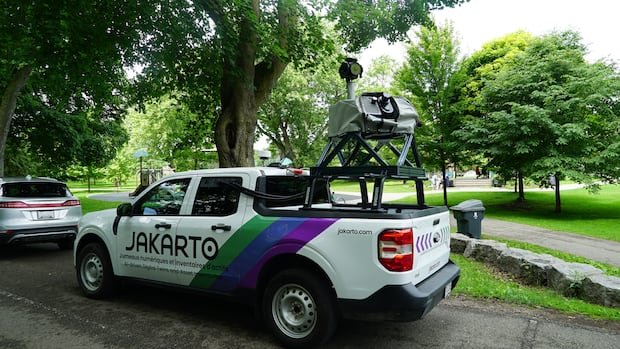

In recent weeks, residents of Guelph have observed vehicles resembling Google Street View cars driving around with prominent cameras on top. These trucks are conducting extensive laser scans of trees lining the streets to construct a detailed three-dimensional virtual map of the city’s tree inventory. The initiative aims to enhance the management of the city’s tree population and work towards achieving a 40 percent tree canopy cover by 2070, according to Dave Beaton, Guelph’s forestry and sustainable landscapes program manager.
Beaton highlighted the importance of accurate data in improving tree management outcomes, emphasizing the necessity for updated information as the current tree inventory is over a decade old. The new system will offer precise details on urban trees, aiding in future planning for several decades ahead.
Equipped with mobile LiDAR scanners, the trucks are capturing intricate measurements of trees, including height, trunk diameter, canopy size, and location, as they traverse neighborhoods. Additionally, data on nearby infrastructure like signs and hydrants is also being collected. This collaborative project involves Jakarto, a Quebec-based mapping company, known for similar endeavors in Cambridge and Burlington.
The scanning trucks are limited to collecting data visible from public roads and do not encroach on private property. All license plates are automatically blurred in the data provided to municipal staff. The gathered information will assist in identifying planting opportunities, refining long-term planning, and focusing on areas with insufficient canopy cover.
Within a span of two months, Guelph anticipates having an updated inventory and a comprehensive 3D virtual map showcasing the city’s urban trees and public infrastructure. Beaton stressed the efficiency of this innovative method compared to traditional approaches, which would have been time-consuming and labor-intensive.
The digital city model created through this process, referred to as a “digital twin,” presents an engineering-grade replica of the urban environment. This tool allows city staff to conduct measurements and inspect infrastructure without physical presence in the field, streamlining asset management and operational processes.
In a similar vein, Cambridge is utilizing comparable technology to inform planning and development decisions. By combining aerial 3D mapping data with street-level scans, the city aims to create a more detailed virtual model that enhances understanding and visualization of proposed developments within the community.
Guelph’s long-term goal of achieving 40 percent tree canopy cover by 2070 necessitates the planting of approximately 3.6 million additional trees. The data collected through this initiative will expedite tree planting efforts, contributing to Guelph’s climate resilience strategy to provide more shade and cooling amid evolving climate conditions.